This was our first hike in Glacier National Park, and I’m glad it was our first. We weren’t real impressed with the hike for about the first two miles until we started getting into the forest. Prior to that, we hiked through a burned-out area, and it reminded us of being back home in California where much of the state’s wilderness areas have suffered from wildfires. But we could see beauty in the distance as we looked to where we were headed.
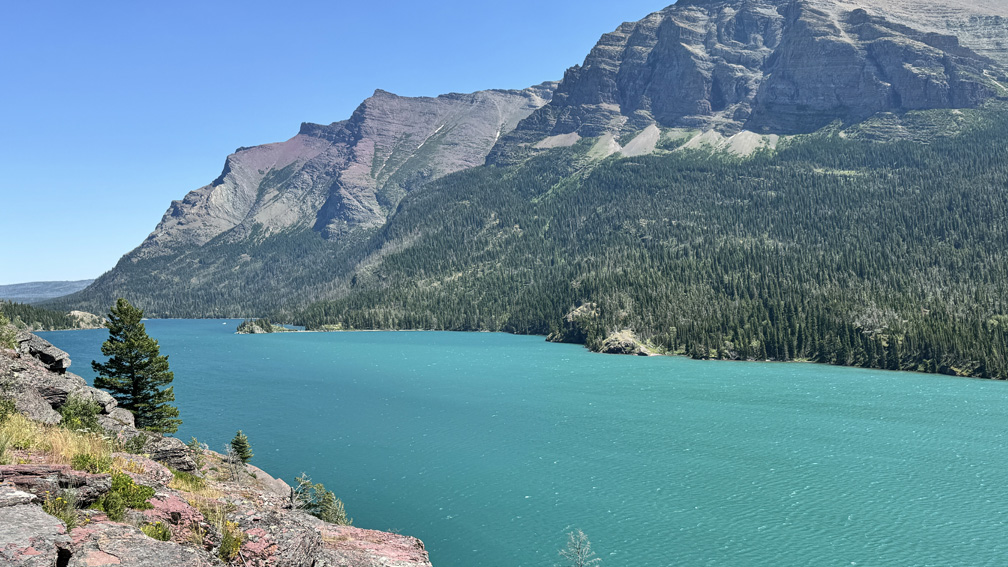
As we hiked along, the view of Saint Mary Lake was quite beautiful with the snowy mountains in the background.
We had to start the hike from the parking area where the Sun Point Nature Trail is, but that is not the trail we hiked. Instead, we headed west on the Piegan Pass Trail to the waterfalls.
The hike was mostly exposed as we hiked under the July sun, but it was not difficult. Not having been to Montana before, and told to carry bear spray with us, we were on a constant lookout for Grizzly Bears (or at least I was).
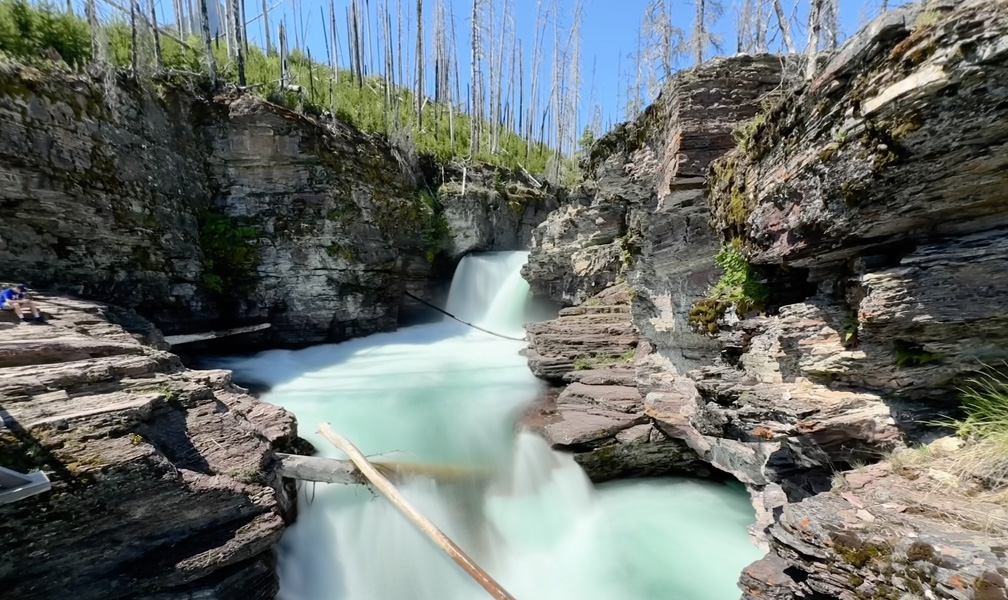
After a little more than half a mile, we came upon Baring Falls. It was nice, but it wasn’t as spectacular as was what was to come. Baring Falls is the first of the three falls. The area was green and unburned around the falls, but as we headed on, we reentered the burn area that surrounded the trail. We hiked on for a little more than 1.75 miles before we came to the second waterfall which was Saint Mary Falls.
This was a more powerful fall with a much more powerful flow than Baring Falls. This is also where many more people were. Around the fall everything was burned, but, the fall itself was definitely worth seeing. The fall was fantastic to take in, but we weren’t there for too long because the area was crowded with hikers and tourists.
After we moved on, the crowd thinned out after the Saint Mary Falls, as that’s where most people seemed to hike to. They came in from a different area on a different trail to join the one we were on that went to Going to the Sun Road where they were transported on park shuttles.
After hiking about another 1,000 feet or so from the falls, we started to enter the forest and were under canopy. Now it felt like a hike that I like to do. This is also where the climbing began to the end point. It’s only about .71 miles over an overall 9.4 percent grade. On paper it doesn’t look bad, and it shouldn’t be, but for some reason it slowed me down, and I had to stop and rest at one point. It wasn’t an elevation issue since the high point was 4,935 feet. I just got tired.
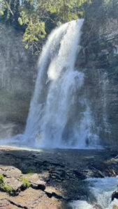
The trail came to a bridge that crossed Virginia Creek, and there was plenty of room to sit and relax by the water. There were several hikers there as well, but nothing as crowded as below. We had our snacks and hung out, and we could look at Lower Virginia Falls, which were spectacular, but there was more to do. After resting, we continued on up to Upper Virginia Falls. There, there was almost nobody, and the falls were powerful and beautiful. From where we looked at it, it was windy and we got hit with the spray from the falls. We stayed and took it in before returning the way we came.
If I were to do this again, I would take the shuttle to the drop-off point, go in on the side trail, and go to Saint Mary Falls and then go to Lower and Upper Virginia Falls. If the area weren’t burned out, I’d do it the way we did the trail. I don’t know when the area burned, but sadly, the forest will not regenerate to what it was in my lifetime.
Directions: From Going to the Sun Road and Camas Road Intersection, drive on Going to the Sun Road for 30.2 miles to the turnoff on the right to the parking area. Parking can be horrendous if not impossible, so it is best to get there very early in the morning. If possible, it might be better to take a park shuttle. Also, see the Glacier National Park site for vehicle reservations or Going to the Sun Road.
The Skinny
Trail: Hiking Peigan Pass To Saint Mary Lake To Upper Virginia Falls
Trailhead Coordinates: 48.676156, -113.581191
Trailhead Elevation: 4576 Feet
Distance: 6.2 Miles – Out And Back
Level Of Difficulty: 🟡
Average Grade: 2.0% – Don’t Let This Fool You. There Is Plenty Of Climbing Along The Way
Steepest Grade: 25% For 102 Feet
Ascension: 826 Feet
Trail Condition: 🟢🟢🟢🟢
Scenery: 🟢🟢🟢
Nearest Town: St. Mary
Challenges: Ascension Grades
Traffic: 🥾🥾🥾
Highlights: Scenery, Waterfalls
Best Time: Summer
Hazards: Exposure
Wildlife Concerns: Black Bears, Grizzly Bears, Mountain Lions, Rattlesnakes
Cell Service: 📵📱
Would I Do This Hike Again?: Yes
Parking: Parking Lot At The Trailhead. $35 To Enter The Park At The Time Of This Writing Good For 7 Days At The Time Of This Writing.
Restrooms: Near The Trailhead