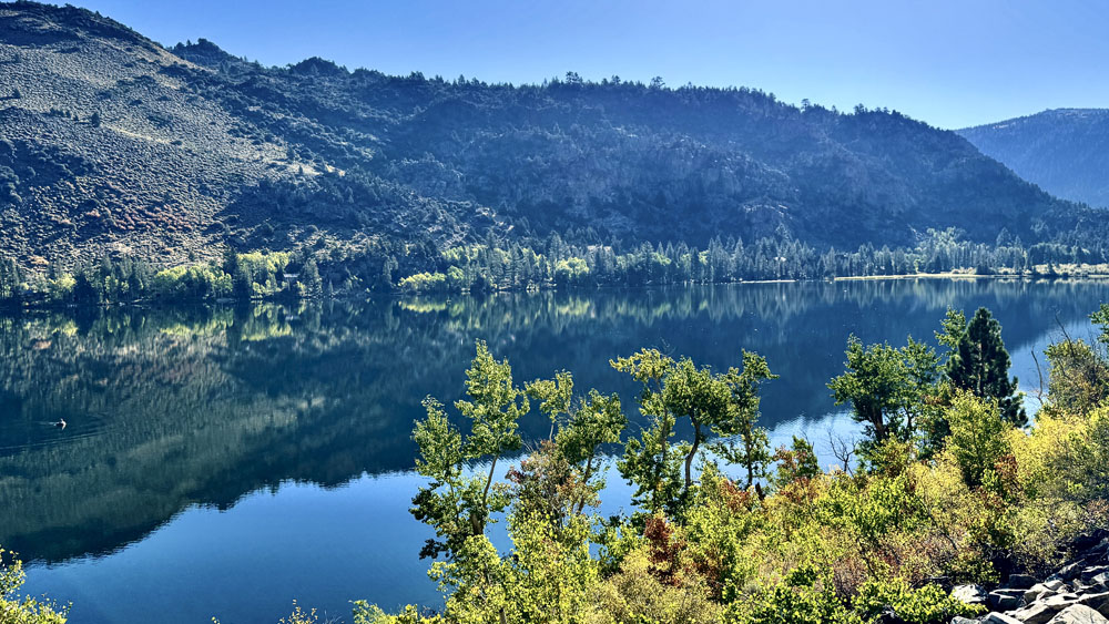
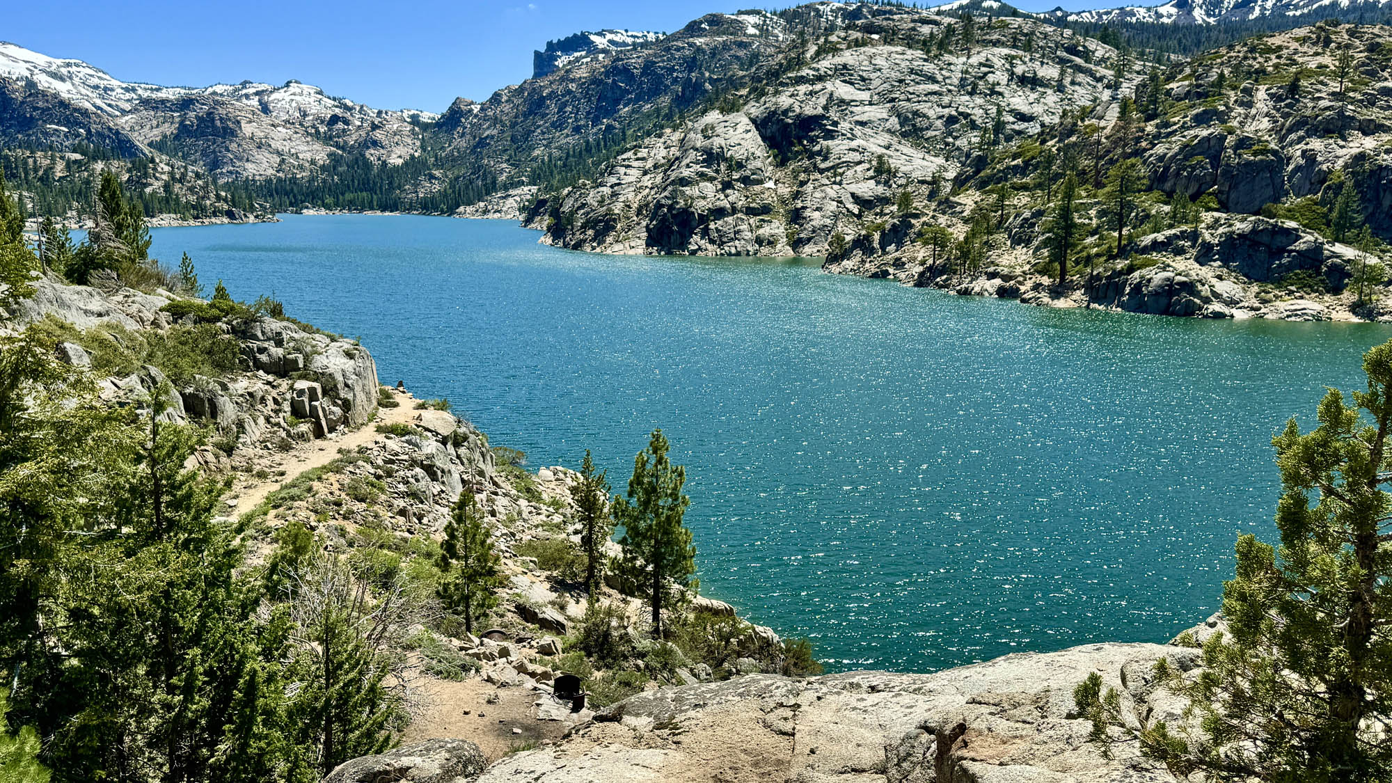
Hiking Upper Ritchey Canyon at Bothe-Napa Valley State Park

The forest at Bothe-Napa Valley State Park on the Upper Ritchey Canyon Trail are recovering from a fire that occurred in 2020.

The hike to Upper Ritchey Canyon at Bothe-Napa Valley State Park is challenging, but along the way you can see a forest that is in recovery from a fire that burned through parts of it in 2020.

Continue reading “Hiking Upper Ritchey Canyon at Bothe-Napa Valley State Park”

Hiking Old Man’s Beard and Sam the Eagle at Moore Creek Park

A trail is cut through an oak forest foothill during the springtime when the grasses are green and lush.
Old Man’s Beard at Moore Creek Park can be green and beautiful in the springtime.

Like the other hikes we’ve done at Lake Hennessey, Old Man’s Beard and Sam the Eagle trails at Moore Creek Park are pleasant when hiked in the springtime with green hills, wildflowers as the foliage is coming back to the trees.

Continue reading “Hiking Old Man’s Beard and Sam the Eagle at Moore Creek Park”

Hiking Desolation Canyon at Death Valley National Park

From the high point of the Desolation Canyon Trail at Death Valley National Park, you can see the Panamint Mountain Range, Telescope Peak, portions of Cottonball Basin, Middle Basin and Badwater Basin.

If you love dirt and sand, Desolation Canyon at Death Valley National Park is for you. If you don’t, the view at the end and colors in the canyon walls is may be worth the hike, but getting there can be a chore.

Continue reading “Hiking Desolation Canyon at Death Valley National Park”

Hiking Lost Palms Trail at Joshua Tree National Park

Hiking to the Lost Palms Oasis at Joshua Tree National Park is like hiking through a garden in the desert.

Hiking to Lost Palms at Joshua Tree National Park is like hiking through a desert garden. If you’re up for hiking through the desert, there really is a lot to see as far as plant life goes on this hike, along with great landscape vistas.

On this hike, you will more than likely come across cholla cacti, indigo bush, jojoba, California juniper, creosote bush, mistletoe, Mojave yucca, Mormon tea, barrel cacti, granite rock, palm trees, but no Joshua trees in this part of the park.

Continue reading “Hiking Lost Palms Trail at Joshua Tree National Park”

Backpacking to Rancheria Falls in Yosemite National Park

Rancheria Falls in Yosemite National Park.
Rancheria Falls in Yosemite National Park can be stunning to watch from a vantage point off the trail leading to the campground.

At the right time of the year, backpacking to Rancheria Falls in Yosemite National Park can be beautiful with wildflowers all around, Wapama Falls with its powerful gushing water, and almost the constant views of the blue waters of the Hetch Hetchy Reservoir.

Continue reading “Backpacking to Rancheria Falls in Yosemite National Park”

Hiking Redbud Trail to Baton Flat

The Redbud Trail meanders through the oak laden hillsides of the Cache Creek Natural Area.

Originally posted June 8, 2018
Updated April 30, 2023

We hiked Redbud Trail in April 2023 after the California’s massive rainstorms earlier in the winter and spring.  What resulted were superblooms in locations. For as often as I have hiked the Redbud Trail, I have never seen the wildflowers on the trail I saw in late April. The wildflowers included Indian Paintbrush, Warrior Paintbrush, Common Fiddlestick, Western Wallflower, Diogene’s Lantern, and many other colorful wildflowers.

Hiking the Redbud Trail as it meanders along hillsides next to oak trees and descends down to Baton Flat and  Cache Creek is a pleasant hike through the foothills.

The trail starts off out of the parking lot on a service road and then to the right you’ll see a sign with Redbud Trail marked on it. Take the trail away from the road and hike along the edge of the foothills until you come to a creek bed that you have to cross. Continue reading “Hiking Redbud Trail to Baton Flat”

Hiking Mountain Trail to Sonoma Mountain Ridge Trail at Jack London State Historic Park

The view from the nearly the end of the Sonoma Mountain Ridge Trail looks into the distance to Mount Diablo.

While the jewel hike at Jack London State Historic Park is the Mountain Trail to its highest point, another good hike is the Sonoma Mountain Ridge Hike.

The hike starts off on the Lake Trail to London Lake from the Upper Parking Lot. As you begin, you hike past a picnic area, winery ruins and the distillery and turn and hike past a vineyard. Follow Mountain Trail which is a service road next to the wooded area. We stayed on Mountain Road as we passed an intersection where another trail leads to the London Lake.

Continue reading “Hiking Mountain Trail to Sonoma Mountain Ridge Trail at Jack London State Historic Park”

Hiking Trojan Point to McKennan Gulch Trail via the Coast Trail at Mount Tamalpais State Park

The view from the Coast Trail on Mount Tamalpais from the north the south can offer a stunning green and blue contrast.

If the weather is right, the views from the Coast Trail on Mount Tamalpais of the Pacific Ocean can be striking. During the right time of the year, the hills are beautifully green with a beautiful blue ocean background to the west, or sweeping green hills as you look north and south.

Continue reading “Hiking Trojan Point to McKennan Gulch Trail via the Coast Trail at Mount Tamalpais State Park”

Hiking Fern Canyon/James Irvine Trail in Northern California

The ancestry of the ferns in Fern Canyon at Prairie Redwoods State Park can be traced back 325 million years.

Fern Canyon on the Northern California Coast is a very green must do hike. The 50-foot high walls are covered with ferns that include lady fern, wood fern, five-finger fern, deer fern, leather leaf fern, and sword fern, and their lineage can be traced back 325 million years. Fern Canyon is beautiful, and as well as the James Irvin Trail.

Continue reading “Hiking Fern Canyon/James Irvine Trail in Northern California”

Hiking the Historic Orchard at Jack London State Historic Park

The Historic Orchard at Jack London State Historic Park once produced apples, apricots, pears, plums, and prunes.

The hike to the Historic Orchard at Jack London State Historic Park is mild. The one-time 100 acre orchard once produced apples, apricots, pears, plums, and prunes. The orchard is a casual hike, but getting there is a hike up and down hills and through forests.

Continue reading “Hiking the Historic Orchard at Jack London State Historic Park”

Hiking Vasquez Rocks Natural Park Area

The iconic Vasquez Rocks, made famous by Star Trek and other films and television are a fantastic place to hike.

See and stand where Captains Kirk and Picard once stood. If you’re a Star Trek fan, you’ll recognize the Vasquez Rocks Natural Area Park where several episodes and movies from the franchise have been filmed over the decades. But it’s also a really neat hiking place. Continue reading “Hiking Vasquez Rocks Natural Park Area”

Hiking Mountain Trail to Cowan Meadow Trail

The view from the high point on Mountain Trail at Jack London State Historic Park is spectacular.

Jack London State Historic Park is becoming one of my favorite places to hike. It has redwoods, oak forests, foothills, ridges and very scenic views. The hike up Mountain Trail to High Point is worth the effort and is spectacular.

The hike starts off on the Lake Trail to London Lake from the Upper Parking Lot. As you begin, you hike past a picnic area, winery ruins and the distillery and turn and hike past a vineyard. Follow Mountain Trail which is a service road next to the wooded area. We stayed on Mountain Road as we passed an intersection where another trail leads to London Lake.

Continue reading “Hiking Mountain Trail to Cowan Meadow Trail”

Hiking Snow Mountain East Peak

The view from Snow Mountain East Peak into the Sacramento Valley.

As when I wrote about my hike to the West Peak of Snow Mountain, the same two words apply: “peaceful desolation,” but the scenery has drastically changed since 2018 when I was there last.

A little less than a month after I hiked to the West Peak, the Ranch Fire broke out, and the area was closed for nearly two years for restoration. Then it was opened it up, but then the August Fire broke out in 2020, and the forest closed back down for a few months.

Continue reading “Hiking Snow Mountain East Peak”

Baton Flat to Wilson Valley (Redbud Trail)

The hike along Redbud Trail takes you through the scenic foothills of the Cache Creek Wilderness Area.

This is a continuation of the Redbud Trail summary I wrote about in 2018. The total length of Redbud Trail (one way) is about 7.5 miles to Wilson Valley where it meets the Judge Davis Trail at Cache Creek. To read about the first 2.5 miles of the hike, see my Redbud Trail to Baton Flat summary. We pick up here at Baton Flat.

Continue reading “Baton Flat to Wilson Valley (Redbud Trail)”

River Canyon Trail at Calaveras Big Trees State Park

"This

River Canyon Trail at Calaveras Big Trees State Park is the poorest maintained trail I’ve ever hiked. Parts of the trail should be closed as a safety hazard due to the poor upkeep of it. If the trail were maintained, this could be a really nice hike through the forest down to the North Fork of the Stanislaus River. Instead, I should have worn my heavier off-trail boots for parts of this trail.

I hate to start the hiking season off with a downer summary, but I want to get the word out before anybody might consider going to this state park.

Continue reading “River Canyon Trail at Calaveras Big Trees State Park”

Hiking Sky Trail to Sculptured Beach at Point Reyes National Seashore

Sky Trail is a beautiful hike meanders along greenery and under pine trees.

Sky Trail at Point Reyes National Seashore is an awesome hike, and at the right time of the year when the wildflowers are in bloom, it’s a feast for the eyes.  For the most part, the hike is not too difficult and is actually relaxing as you hike under the pine forests next to ferns and greenery.

Continue reading “Hiking Sky Trail to Sculptured Beach at Point Reyes National Seashore”

Hiking Bear Valley to Kelham Beach at Point Reyes National Seashore

Sandy Kelham Beach at Point Reyes National Seashore is backed by a cliff wall along its expanse.

Bear Valley Trail is probably the most popular trail at Point Reyes National Seashore, and I’ve hiked it countless times. This family-friendly trail is wide and follows the Bear Valley Creek under lush canopy almost all the way where it intersects with the Coast Trail.

Continue reading “Hiking Bear Valley to Kelham Beach at Point Reyes National Seashore”

Hiking Smittle Creek Trail

Lake Berryessa
Lake Berryessa

The hike on the Smittle Creek Trail is an easy rolling hill hike along the shores of Lake Berryessa, but it really isn’t that impressive. I hiked it in the fall, but it may come alive in the spring when the hills are green and wildflowers are in bloom. I’m told this trail is popular with birdwatchers. I’m not knocking this trail… it has its place, and viewed in context, it makes for a pleasant Sunday stroll with a picnic by the lake. Continue reading “Hiking Smittle Creek Trail”

Hiking to Lake Margaret

Lake Margaret is surrounded by granite on most of its shores.

Lake Margaret is a beautiful back country lake in the Eldorado National Forest just 2.5 miles from the trailhead.

But don’t let that short mileage fool you. While the hike is pleasant and moves through forested areas, next to small bodies of water, and during the right time of year it is very flowery and green. There are, however, some challenges to overcome. Continue reading “Hiking to Lake Margaret”

Hiking to Scott’s Lake is full of Fall Color

The fall color along the trail to Scott's Lake can be unbelievable.
The fall color along the trail to Scott’s Lake can be unbelievable.

If you hike the trail to Scott’s Lake in the fall when the aspens are turning color, it will knock your socks off.

The hike starts off at the trailhead parking lot just off Highway 89 on Luther Pass, which is part of the larger Tahoe Rim Trail. You hike a pleasant .1 a mile before you come upon Highway 89 and have to cross it. Listen for traffic, as you should be able to hear it before you can see it coming around the two corners. Continue reading “Hiking to Scott’s Lake is full of Fall Color”

Hiking Fleming Trail Loop in Eldorado National Forest

Hiking among the trees on the Fleming Loop in the Eldorado National Forest is a place that offers peaceful contemplation.

If you’re in the frame of mind for this type of trail, the Fleming Meadow Loop rocks. There are no sweeping vistas, not an abundance of wildflowers or much running water – just a hike among the trees in some areas with very dense forest. My experience was awesome for contemplation and meditation.

The Fleming Meadow Loop in the Eldorado National Forest is one of the best marked and maintained trails I’ve come across in a national forest. When you hike Trail 8, you will come across many junctions with roads and other trails, but Trail 8 is marked so it is easy to follow. This trail is taken advantage of by hikers, mountain bikers, equestrian riders and the locals who know its secret. Continue reading “Hiking Fleming Trail Loop in Eldorado National Forest”

Hiking Prospect Peak in Lassen Volcanic National Park

Mt. Lassen through a smokey haze from Prospect Peak.

What makes the hike up to Prospect Peak in Lassen Volcanic National Park worth the effort are the views from the 8340-foot summit. First, I have to admit, the views would have been spectacular when I was there, but there were several wildfires burning at the time. The Carr Fire near Redding and the Whaleback Fire near Susanville along with others in the state made for very hazy views when the wind blew in the smoke. Continue reading “Hiking Prospect Peak in Lassen Volcanic National Park”

Hiking the Steep Ravine Trail – Dipsea Trail Loop

The Steep Ravine Trail on Mount Tamalpias follows Webb Creek through a lush Redwood forest.

If you like hiking under Redwood trees next to running water and waterfalls, then the Steep Raving Trail is the hike for you if you do it at the right time of the year. By that, it’s good to go during or after a good rain when the waterfalls will be flowing.

The trail is called Steep Ravine for a reason. You will descend 1,084 feet on a 9 percent grade slightly over 2 miles. For the most part, it’s gentle, but the beginning is steep. If the water is running, it’s worth it. Continue reading “Hiking the Steep Ravine Trail – Dipsea Trail Loop”

Hiking Eagle Pass to Paul Thomas Trail

Black Butte Lake from Eagle Pass is a green and alive in the springtime.

The hike from Eagle Pass to the Paul Thomas Trail can only be done in the springtime while the grasses are green before the summer sets in and the weather is still cool enough to be outside in the valley. The view from Eagle Pass you hike up to is incredible. It looks over to Black Butte, the lake itself to the west and the Coastal Mountain Range that spans the horizon running from the north the south that disappears to sight. Continue reading “Hiking Eagle Pass to Paul Thomas Trail”

Hiking Snow Mountain West Peak

The Sutter Buttes, the Sacramento Valley and the Sierra Nevadas can be seen in the distance from Snow Mountain.

Note: This portion of the forest was severely burned in 2018 shortly after I hiked it, and most the trees are now burned out. See my Snow Mountain East Peak summary for an update.

Peaceful desolation. That’s what the hike up Snow Mountain in the Snow Mountain Wilderness is. The trails are defined, the wildflowers are in bloom in the summer and people are scarce. The trails in this Northern California area are a hidden gem, as they are under-hiked and seemingly unknown to most.

Though not recommended to hike in the summer as the heat can be brutal, I happened to catch the mountain on an unseasonably cool July day with overcast and a smattering of rain. The wildflowers were in bloom from red to purple, yellow, blue and orange. The hike starts out exposed and meanders for a little more than a mile before you start to get under the cover of the tall pine trees as you climb.

Continue reading “Hiking Snow Mountain West Peak”

Hiking Polomarin Trailhead to Wildcat Camp (Coast Trail)

The Coast Trail offers sweeping views of the Pacific Ocean.

Hiking the Coast Trail from the Polomarin trailhead to Wildcamp Camp is like hiking Highway 1. It’s extraordinary with its views of the ocean on one side and forests on the other.

Most take this trail to hike to Alamere Falls, where the trail offshoot is at nearly four miles in. At the time I took this trail, the Alamere Falls cutoff was mostly overgrown and difficult to ascertain. It seemed like it wasn’t being well-maintained. Some say there is a sign there, but I did not see one when I hiked by, but someone made an arrow marker on the ground (not permanent) marking the intersection. Part of the overgrowth was poison oak, but nonetheless that doesn’t deter people from hiking to the falls. But if you go on, there’s more to see. Continue reading “Hiking Polomarin Trailhead to Wildcat Camp (Coast Trail)”

Upper Bidwell Park: North Rim Trail to Middle Trail

The North Rim Trail in Upper Bidwell Park comes alive with color in the springtime.

It isn’t often that I hike a city park and let alone write about it, but Upper Bidwell Park in Chico is laden with hiking trails in the hills is an exception. Over the years I’ve heard so much about the hiking trails in Upper Bidwell Park, I finally decided to check it out in the spring. I hiked the North Rim Trail and Middle Trail Loop. Continue reading “Upper Bidwell Park: North Rim Trail to Middle Trail”

Hiking High Bridge Trail

The views of the summer foothills from High Bridge Trail can be staggering at times.

The High Bridge Trail hike starts off on a brief service road going down to Bear Creek. Follow the trail signs, and they will point you to where the crossing should be, and you can see where the trail picks up on the other side of the creek. However, depending on what the water level is like, you may not be able to safely cross, and you may have to improvise your own way. If the water is running, you will have to use your own best judgment as to if crossing is wise, or if you should try it at another time. Continue reading “Hiking High Bridge Trail”

Billy’s Hill and Glascock Mountain

The north end of Capay Valley from Glascock Mountain where some of the farms can be seen.

The hike up Billy’s Hill and then over to Glascock Mountain can be a butt kicker, but it is worth it. This land is overseen by the Bureau of Land Management, so you can hike on it. Once you climb over the green gate, you will see there is no trail up Billy’s Hill, so the best way, albeit steep, is to hike a game trail. You may have to stop and rest on the up, which took me a little more than an hour to climb the 19 percent one-mile grade. The 980 foot ascent takes you from a starting elevation of 798 feet to 1778 feet. Continue reading “Billy’s Hill and Glascock Mountain”

Carson Pass to Fourth of July Peak

A summer wildflower explosion of color lines the trail from Carson Pass to Winnemucca Lake with Round Top Mountain the background.

Ihave written about hiking to Round Top Lake and Winnemucca Lake in a previous post, but I want to revisit the hike from a different way. If you like summer wildflowers, this is absolutely the hike for you.

Instead of starting out at Woods Lake, on this hike you start from Carson Pass, just a few more miles up on Highway 88.

The wildflower display on the trail to Winnemucca Lake, I’m told, is “world renowned.” I don’t know if that’s true, but I can attest to the beauty along the trail to the lake like I’ve never encountered on in the wild before. There is lupine, Indian Paintbrush, and a host of flowers I don’t know the names of, but are blue, purple, yellow and white. It’s an explosion of color, and in all the times I’ve hiked this trail, I’ve seen not only hikers, but photographers out on the trail too. About 1.5 miles in, you get into the wildflower burst. There is some uphill, but it’s not bad to this point, so it’s more than worth going just for this. If you were to just go to Winnemucca Lake and turn back, the wildflowers alone would make it a five-star day and the lake a bonus. Continue reading “Carson Pass to Fourth of July Peak”

Carson Emigrant National Recreation Trail

The Carson Emigrant National Recreation Trail offers scenic views of Caples Lake and the surrounding mountains.

The Carson Emigrant National Recreation Trail is not too often hiked but is a walk with history. As you hike it, it’s difficult to imagine how thousands of people in covered wagons made it along this terrain, and this trail isn’t anywhere near other difficult terrain they encountered on their way up Covered Wagon Peak. You won’t go that far if you turn around where I did, but you can. Continue reading “Carson Emigrant National Recreation Trail”

Hiking Big Meadow Trail to Round Lake

Big Meadow is vast and the trail cuts through it on the way to Round Lake.

If you like hiking through meadows like I do, then this hike through Big Meadow is absolutely for you.

The hike starts off at the Big Meadow trailhead parking lot just off Highway 89 on Luther Pass, which is part of the larger Tahoe Rim Trail. You hike a pleasant .1 a mile before you come upon Highway 89 and have to cross it. Listen for traffic, as you should be able to hear it before you can see it coming around the corners. Continue reading “Hiking Big Meadow Trail to Round Lake”

Hiking Valley Vista Trail

The view from Valley Vista Trail overlooks a northern portion of Capay Valley with Cache Creek running below it.

The hike up to Valley Vista Trail can be heart pounding in areas and seemingly level in others while you ascend the entire time. On a clear day while hiking, you can see the Sutter Buttes, portions of the north end of Capay Valley, the Sacramento Valley and the Sierras way out to the east. Continue reading “Hiking Valley Vista Trail”

Stevens Trail Along the American River

The American River Canyon from the Stevens Trail.

The Stevens Trail just outside of Colfax starts off pleasantly as you hike amongst lush greenery on both sides of the trail under the shade from oak tree canopy. The 1400 foot 3.7 mile descent to the American River is gentle, and the traffic sounds of the traffic on Interstate 80 fade into the distance as you venture away from the trailhead. Continue reading “Stevens Trail Along the American River”

Hiking Around Loon Lake

Loon Lake from the trail.

There’s nothing difficult about hiking this scenic trail along Loon Lake on the Rubicon Trail, which offers picturesque images of the lake if you venture off the forested trail a little bit for the views. Along the way you will hike past granite rocks and hills as the trail is a gateway to Desolation Wilderness. This hike is purely about the scenery and not much of a challenge, as the trail is nicely maintained. Continue reading “Hiking Around Loon Lake”

Hiking The Mount Konocti Trail

Buckingham Peak with Clear Lake in the background from Wright Peak on Mount Konocti.

Hiking up Mount Konocti to Wright Peak is about a six-mile round-trip hike from the Upper Parking Lot near the access gate on Konocti Road. You will climb approximately 1,600 feet, and along the way, you hike past past walnut and apple orchards, through an amazing Canyon Oak grove to the Mary Downen cabin, which was built in 1903 and preserved. The trail continues up to Wright Peak to the no longer used CalFire lookout tower. You can also hike to Buckingham Peak and Howard Peak, which would make the entire mountain nearly a 9-mile hike. Continue reading “Hiking The Mount Konocti Trail”