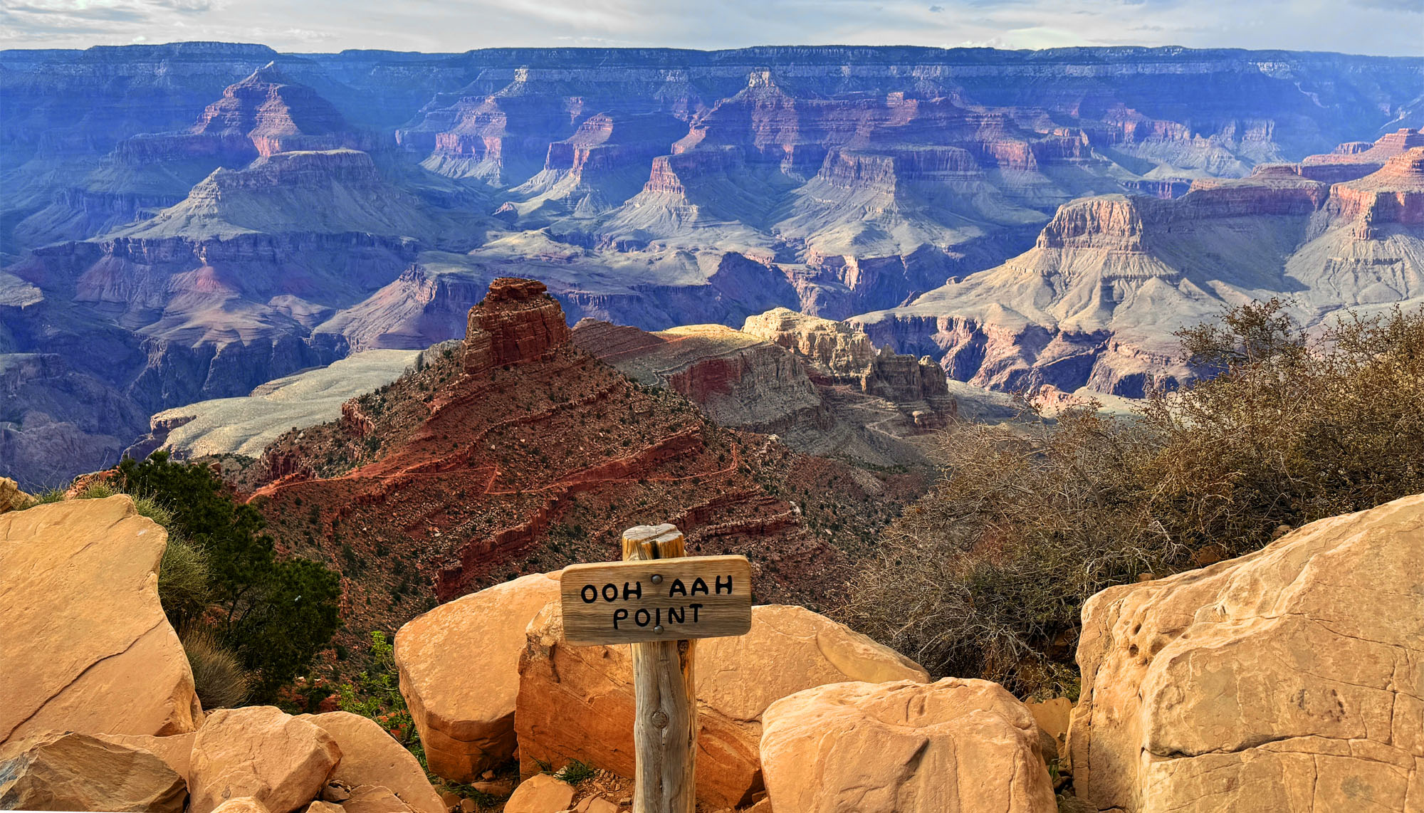
The Arnold Rim Trail is a hike through a part of the Stanislaus National Forest that leads to a fantastic point dubbed the “The Top of the World” where the view is incredible. From the Sierras, you can see over to the Coastal Range and Mount Diablo nearly 90 miles away on a clear day.
The Grand Canyon of the Yellowstone is an incredible sight to see and hike along in Yellowstone National Park. From different vantage points, you can marvel at Lower Yellowstone Falls. The forest along the hike was tranquil and mediative, and once we left the crowds, we probably saw a little more than a dozen people.
The hike from Yosemite Valley up to Vernal Falls and then over to Nevada Falls is incredible, and one of many of many spectacular attractions of Yosemite National Park. But even hiking through the beauty of the forests, it does take work to make it to the top of either waterfall.
The Steep Ravine Trail at Mount Tamalpais State Park is a beautiful trail to hike, and I’ve written about it previously. I combined this trail with the Matt Davis Trail to make a loop on the west side of Mount Tamalpais.
The hike to Bear Gulch Reservoir at Pinnacles National Park starts off on the High Peaks Trail as you hike under oak trees and ascend to the Moses Spring Trail junction.
As the trail ascends, you start to hike amongst rock formations that take you to the caves on the Moses Spring Trail. If you are not comfortable with caves, there is a bypass trail that will also take you to Bear Gulch Reservoir on up past the Moses Spring Trail junction that leads to the Rim Trail, but the caves are worth exploring. Continue reading “Hiking Moses Spring Trail to Bear Gulch Reservoir at Pinnacles National Park”
Meadow Trail at Point Reyes National Seashore up to Sky Trail is a tough climb, but sometimes the rewards are great if you like wildlife. Both times I hiked the trail I was treated to seeing Black Tail Deer once in a meadow and once running in the forest.
Hiking the Carbon River Trail in the northwest corner of Mount Rainier is pretty easy-going. You will hike next to old-growth Douglas-fir trees while hiking through a densely green rainforest.
Boy Scout Trail in Jedediah Smith Redwoods State Park is a beautiful hike amongst the ferns and redwood trees. The trail leads to a massive redwood tree, called “Boy Scout Tree” and then a waterfall.
Andrew Molera State Park at Big Sur offers beautiful views of the Pacific Ocean and the nearby mountains. While the hike to see some of the views is challenging in places, it is worth it.
In 2021, the Dixie Fireburned much of the area, so the landscape may be different now than when we were there about a month or so before the fire occurred.
Hiking to Spanish Peak from Silver Lake in the Plumas National Forest is not easy, but the views are a spectacular payoff. The terrain is diverse. You start off in the forested area at Silver Lake, then you hike exposed over granite as you climb, and then you hike through forested areas again.
Cronan Ranch Regional Trails Park is a playground of trails in the foothills. We hiked in the valleys and over high points that showed off the snowcapped Sierra Nevada Mountain range in the distance.
On this hike, we covered portions of several trails on our 11.5 mile hike. We hiked the River Trail to the Gerle Loop Trail; Down and Up Trail to the Cronan Ranch Road; South Fork American River Trail to the West Ridge Trail. We hiked back to the Cronan Ranch Road and the Down & Up Trail to Sky Ridge Trail. We reconnected with the Connector Trail and back to the Gerle Loop Trail. Wow, that’s a lot of trails!
The trail up to Lassen Peak is loaded with switchbacks and is nothing but a climb, but the trail itself is very nicely maintained and views get better and better the higher you go. Once you reach the top, you should feel a real sense of accomplishment.
Virginia Lakes in the Eastern Sierra’s is a feast for the eyes but a workout on the lungs. The peak on this trail reaches approximately 11,120 feet give or take, with a starting elevation of 9,846 feet.
Deafy Glade Trail is a butt kicker. After about a mile in and a creek crossing, it’s 3.5 miles of climbing that pulls on your calves, hamstrings and other lower body muscles. If you want buns of steel, this trail can make it happen for you. The view from the top where the Deafy Glade Trail meets the Summit Springs Trail offers views down into the Sacramento Valley and even the Sutter Buttes on a clear day.
From the trailhead, the hike to Meiss Meadow follows the Pacific Crest Trail to the Upper Truckee River you’ll have to cross and proceed up to the Showers Lake.
Lake Sylvia is a beautiful lake at 8050 feet in the Sierra Nevadas at the base of Pyramid Peak. The lake is small and beautiful, and the water is clear. It’s also idyllic and lined by pine trees on all but the northeast end, where you can look up at Pyramid Peak.
How can you be a hiker in Northern California and not hike to Feather Falls? The falls are an awesome to sight to behold, and the hike isn’t so bad either – depending on when you go and the condition of the trail. At about .4 miles from the trailhead, you’ll have decision to make when you come to fork.
If you want to make a loop out of this hike, it might be best to go to the left, as the trail will head downhill. Coming back up this way could be strenuous. If you do decide to come back up this way, there are a series of benches along the trail for resting. This way is shorter taking about 3.3 miles to get to the overlook. Continue reading “Hiking to Feather Falls”
Horseshoe Lake in Lassen Volcanic National Park offers an awesome view, and is what makes this hike worth it. I got to experience the lake early in the morning before I saw any other hikers. It was beautiful, and even though I consider the entire hike the destination, just looking at Horseshoe Lake is a destination. Continue reading “Hiking Juniper Lake to Horseshoe Lake”
I love this hike! Hiking the Blue Ridge Trail to Fiske Peak in Northern California starts with a mild climb through an oak forest. It’s the only canopy you’ll be under during the hike. As the trail meanders up the open hillside, you’ll hike into a clear view of Glascock Mountain across the highway. Once you get to this point, the real ascension quickly begins. Continue reading “Hiking Blue Ridge Trail to Fiske Peak”
This sometimes heavy breather of a hike to Thunder Mountain has outstanding views of mountaintops and ranges and overlooks vast swaths of trees and granite, meadows and forested hiking. At slightly over three miles in, and after some of the heaviest climbing on the trail, you come to the vista that can make you stop hiking and just gaze at the landscape. As you look to the south, you can see mountain peaks in the distance – probably in the Stanislaus National Forest – some with snow on them. If there are clouds in the over them, it’s an even more powerful view. Continue reading “Hiking Thunder Mountain”
Ihave written about hiking to Round Top Lake and Winnemucca Lake in a previous post, but I want to revisit the hike from a different way. If you like summer wildflowers, this is absolutely the hike for you.
Instead of starting out at Woods Lake, on this hike you start from Carson Pass, just a few more miles up on Highway 88.
The wildflower display on the trail to Winnemucca Lake, I’m told, is “world renowned.” I don’t know if that’s true, but I can attest to the beauty along the trail to the lake like I’ve never encountered on in the wild before. There is lupine, Indian Paintbrush, and a host of flowers I don’t know the names of, but are blue, purple, yellow and white. It’s an explosion of color, and in all the times I’ve hiked this trail, I’ve seen not only hikers, but photographers out on the trail too. About 1.5 miles in, you get into the wildflower burst. There is some uphill, but it’s not bad to this point, so it’s more than worth going just for this. If you were to just go to Winnemucca Lake and turn back, the wildflowers alone would make it a five-star day and the lake a bonus. Continue reading “Carson Pass to Fourth of July Peak”
Normally, I wouldn’t rate a hiking trail like Round Top Lake to Winnemucca Lake with a 🟠. It’s not a difficult hike, but the altitude might slow you down as you approach the 9000-foot mark. Even if it makes you huff and puff, it’s well worth it.
This hike has fantastic views as you approach Round Top Lake and look behind you to the north down on Caples Lake and the mountains beyond. Leaving the small parking lot, you’ll cross over Woods Creek on a bridge and then shortly after you’ll leave the pavement to your right and start hiking the trail. Continue reading “Round Top Lake to Winnemucca Lake”
Though short, hiking up Lovers Leap trail is one tough climb. You start to feel the pull almost immediately once stepping onto the trail, and it doesn’t stop until you make it almost to the top as you hike under thick pine most of the way. Following the trail takes you to the top of the end point, which is the highlight of the trail. Continue reading “Hike Lovers Leap Trail”
Hiking to the Annie’s Trail trailhead can be a feat within itself, as you have to hike the Homestead Trail and climb many steps up a 19 percent grade over 400 feet to get to it. By the time you reach the trailhead, you’ve already hiked about two miles overall. Once you’ve made it this far, you’ll find yourself at a junction. To take Annie’s Trail, hike straight ahead and follow the trail south along an ascending path. You’ll do some ducking under limbs, but it’s not bad. Continue reading “Hiking Annie’s Trail”
Exploring the Stebbins Cold Canyon Loop, (also called the Homestead-Blue Ridge Loop or the Homestead Blue Ridge Trail), starts off easy as you hike through the canyon, but it becomes a workout as you ascend to the great views of Lake Berryessa. I have hiked this trail more times than I can count, and I will continue to hike it. I love it for its views and its challenge.