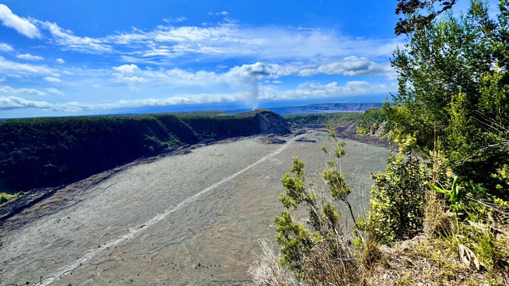
Hiking Upper Ritchey Canyon at Bothe-Napa Valley State Park

The forest at Bothe-Napa Valley State Park on the Upper Ritchey Canyon Trail are recovering from a fire that occurred in 2020.

The hike to Upper Ritchey Canyon at Bothe-Napa Valley State Park is challenging, but along the way you can see a forest that is in recovery from a fire that burned through parts of it in 2020.

Continue reading “Hiking Upper Ritchey Canyon at Bothe-Napa Valley State Park”

Hiking Grand Canyon Of The Yellowstone To Ribbon Lake

Lower Yellowstone Falls from Artist Point.
The view from Artist Point at Yellowstone National Park of Lower Yellowstone Falls and the Grand Canyon of the Yellowstone can be spectacular.

The Grand Canyon of the Yellowstone is an incredible sight to see and hike along in Yellowstone National Park. From different vantage points, you can marvel at Lower Yellowstone Falls. The forest along the hike was tranquil and mediative, and once we left the crowds, we probably saw a little more than a dozen people.

Continue reading “Hiking Grand Canyon Of The Yellowstone To Ribbon Lake”

Hiking Mirror Lake in Yosemite National Park

Mirror Lake at Yosemite National Park.
The scenery at Mirror Lake at Yosemite National Park can be stunning.

Mirror Lake in Yosemite National Park is a beautiful hike that is pretty easy and hikes through forests and next to big granite rocks. Upper and Lower Mirror Lake live up to their name where the reflections in the water of the landscape around them can be gorgeous.

There are several places you can start the hike from, and we jumped on the Yosemite Valley Loop Trail off of Ahwahnee Drive about .34 miles short of the Ahwahnee Hotel. The Mirror Lake hike itself is about a 2.4 mile loop, but we wanted to make a longer hike out of it, so we ended up hiking 7.2 miles.

Continue reading “Hiking Mirror Lake in Yosemite National Park”

Mist Trail To Nevada Fall in Yosemite National Park

Nevada Fall in Yosemite National Park from a distance running down the granite rock with forest trees in the fore and background.
Nevada Fall in Yosemite National Park is a stunning waterfall.

The hike from Yosemite Valley up to Vernal Falls and then over to Nevada Falls is incredible, and one of many of many spectacular attractions of Yosemite National Park. But even hiking through the beauty of the forests, it does take work to make it to the top of either waterfall.

Continue reading “Mist Trail To Nevada Fall in Yosemite National Park”

Hiking Steep Ravine/Matt Davis Loop at Mount Tamalpais State Park

The Matt Davis Trail at Mount Tamalpais offers sweeping views of the Pacific Ocean.

The Steep Ravine Trail at Mount Tamalpais State Park is a beautiful trail to hike, and I’ve written about it previously. I combined this trail with the Matt Davis Trail to make a loop on the west side of Mount Tamalpais.

Continue reading “Hiking Steep Ravine/Matt Davis Loop at Mount Tamalpais State Park”

Hiking Trojan Point to McKennan Gulch Trail via the Coast Trail at Mount Tamalpais State Park

The view from the Coast Trail on Mount Tamalpais from the north the south can offer a stunning green and blue contrast.

If the weather is right, the views from the Coast Trail on Mount Tamalpais of the Pacific Ocean can be striking. During the right time of the year, the hills are beautifully green with a beautiful blue ocean background to the west, or sweeping green hills as you look north and south.

Continue reading “Hiking Trojan Point to McKennan Gulch Trail via the Coast Trail at Mount Tamalpais State Park”

Hiking Meadow Trail to Mt. Wittenberg Trail at Point Reyes National Seashore

While the grasses and some of the undergrowth along the trails in the Meadow Trail/Mt. Wittenberg Trail area at Point Reyes National Seashore are green, many of the trees are burned out from a 2020 fire that swept through the area.

Meadow Trail at Point Reyes National Seashore up to Sky Trail is a tough climb, but sometimes the rewards are great if you like wildlife. Both times I hiked the trail I was treated to seeing Black Tail Deer once in a meadow and once running in the forest.

Continue reading “Hiking Meadow Trail to Mt. Wittenberg Trail at Point Reyes National Seashore”

Hiking Fern Canyon/James Irvine Trail in Northern California

The ancestry of the ferns in Fern Canyon at Prairie Redwoods State Park can be traced back 325 million years.

Fern Canyon on the Northern California Coast is a very green must do hike. The 50-foot high walls are covered with ferns that include lady fern, wood fern, five-finger fern, deer fern, leather leaf fern, and sword fern, and their lineage can be traced back 325 million years. Fern Canyon is beautiful, and as well as the James Irvin Trail.

Continue reading “Hiking Fern Canyon/James Irvine Trail in Northern California”

Hiking Creamery Meadow, Bluffs, Panorama and Ridge Trail at Andrew Molera State Park

The view from Panoramic Trail looking over the Pacific Ocean from above the marine layer.

Andrew Molera State Park at Big Sur offers beautiful views of the Pacific Ocean and the nearby mountains. While the hike to see some of the views is challenging in places, it is worth it.

Continue reading “Hiking Creamery Meadow, Bluffs, Panorama and Ridge Trail at Andrew Molera State Park”

Hiking the Historic Orchard at Jack London State Historic Park

The Historic Orchard at Jack London State Historic Park once produced apples, apricots, pears, plums, and prunes.

The hike to the Historic Orchard at Jack London State Historic Park is mild. The one-time 100 acre orchard once produced apples, apricots, pears, plums, and prunes. The orchard is a casual hike, but getting there is a hike up and down hills and through forests.

Continue reading “Hiking the Historic Orchard at Jack London State Historic Park”

Hiking Sunset Trail, Mount Livermore and North Ridge Trail on Angel Island

The views from the top of Angel Island offer a 360 degree view of the San Francisco Bay.

The views from the top of Mount Livermore on Angel Island State Park of the San Francisco Bay are incredible on a clear day. You can see the San Francisco Skyline, the East Bay, the Golden Gate Bridge and the hills of Marin County and much more.

Continue reading “Hiking Sunset Trail, Mount Livermore and North Ridge Trail on Angel Island”

Hiking Mountain Trail to Cowan Meadow Trail

The view from the high point on Mountain Trail at Jack London State Historic Park is spectacular.

Jack London State Historic Park is becoming one of my favorite places to hike. It has redwoods, oak forests, foothills, ridges and very scenic views. The hike up Mountain Trail to High Point is worth the effort and is spectacular.

The hike starts off on the Lake Trail to London Lake from the Upper Parking Lot. As you begin, you hike past a picnic area, winery ruins and the distillery and turn and hike past a vineyard. Follow Mountain Trail which is a service road next to the wooded area. We stayed on Mountain Road as we passed an intersection where another trail leads to London Lake.

Continue reading “Hiking Mountain Trail to Cowan Meadow Trail”

Hiking Snow Mountain East Peak

The view from Snow Mountain East Peak into the Sacramento Valley.

As when I wrote about my hike to the West Peak of Snow Mountain, the same two words apply: “peaceful desolation,” but the scenery has drastically changed since 2018 when I was there last.

A little less than a month after I hiked to the West Peak, the Ranch Fire broke out, and the area was closed for nearly two years for restoration. Then it was opened it up, but then the August Fire broke out in 2020, and the forest closed back down for a few months.

Continue reading “Hiking Snow Mountain East Peak”

River Canyon Trail at Calaveras Big Trees State Park

"This

River Canyon Trail at Calaveras Big Trees State Park is the poorest maintained trail I’ve ever hiked. Parts of the trail should be closed as a safety hazard due to the poor upkeep of it. If the trail were maintained, this could be a really nice hike through the forest down to the North Fork of the Stanislaus River. Instead, I should have worn my heavier off-trail boots for parts of this trail.

I hate to start the hiking season off with a downer summary, but I want to get the word out before anybody might consider going to this state park.

Continue reading “River Canyon Trail at Calaveras Big Trees State Park”

Hiking Sky Trail to Sculptured Beach at Point Reyes National Seashore

Sky Trail is a beautiful hike meanders along greenery and under pine trees.

Sky Trail at Point Reyes National Seashore is an awesome hike, and at the right time of the year when the wildflowers are in bloom, it’s a feast for the eyes.  For the most part, the hike is not too difficult and is actually relaxing as you hike under the pine forests next to ferns and greenery.

Continue reading “Hiking Sky Trail to Sculptured Beach at Point Reyes National Seashore”

Hiking Bear Valley to Kelham Beach at Point Reyes National Seashore

Sandy Kelham Beach at Point Reyes National Seashore is backed by a cliff wall along its expanse.

Bear Valley Trail is probably the most popular trail at Point Reyes National Seashore, and I’ve hiked it countless times. This family-friendly trail is wide and follows the Bear Valley Creek under lush canopy almost all the way where it intersects with the Coast Trail.

Continue reading “Hiking Bear Valley to Kelham Beach at Point Reyes National Seashore”

Hiking to Lake Margaret

Lake Margaret is surrounded by granite on most of its shores.

Lake Margaret is a beautiful back country lake in the Eldorado National Forest just 2.5 miles from the trailhead.

But don’t let that short mileage fool you. While the hike is pleasant and moves through forested areas, next to small bodies of water, and during the right time of year it is very flowery and green. There are, however, some challenges to overcome. Continue reading “Hiking to Lake Margaret”

Hiking to Scott’s Lake is full of Fall Color

The fall color along the trail to Scott's Lake can be unbelievable.
The fall color along the trail to Scott’s Lake can be unbelievable.

If you hike the trail to Scott’s Lake in the fall when the aspens are turning color, it will knock your socks off.

The hike starts off at the trailhead parking lot just off Highway 89 on Luther Pass, which is part of the larger Tahoe Rim Trail. You hike a pleasant .1 a mile before you come upon Highway 89 and have to cross it. Listen for traffic, as you should be able to hear it before you can see it coming around the two corners. Continue reading “Hiking to Scott’s Lake is full of Fall Color”

Hiking Lyons Creek Trailhead to Lake Sylvia

Lake Sylvia with its clear water sits up high at 8050 feet in Desolation Wilderness.

Lake Sylvia is a beautiful lake at 8050 feet in the Sierra Nevadas at the base of Pyramid Peak. The lake is small and beautiful, and the water is clear. It’s also idyllic and lined by pine trees on all but the northeast end, where you can look up at Pyramid Peak.

Continue reading “Hiking Lyons Creek Trailhead to Lake Sylvia”

Hiking Fleming Trail Loop in Eldorado National Forest

Hiking among the trees on the Fleming Loop in the Eldorado National Forest is a place that offers peaceful contemplation.

If you’re in the frame of mind for this type of trail, the Fleming Meadow Loop rocks. There are no sweeping vistas, not an abundance of wildflowers or much running water – just a hike among the trees in some areas with very dense forest. My experience was awesome for contemplation and meditation.

The Fleming Meadow Loop in the Eldorado National Forest is one of the best marked and maintained trails I’ve come across in a national forest. When you hike Trail 8, you will come across many junctions with roads and other trails, but Trail 8 is marked so it is easy to follow. This trail is taken advantage of by hikers, mountain bikers, equestrian riders and the locals who know its secret. Continue reading “Hiking Fleming Trail Loop in Eldorado National Forest”

Hiking to Feather Falls

Feather Falls in Butte County plummets more than 400 feet down into the Feather River.

How can you be a hiker in Northern California and not hike to Feather Falls? The falls are an awesome to sight to behold, and the hike isn’t so bad either – depending on when you go and the condition of the trail. At about .4 miles from the trailhead, you’ll have decision to make when you come to fork.

If you want to make a loop out of this hike, it might be best to go to the left, as the trail will head downhill. Coming back up this way could be strenuous. If you do decide to come back up this way, there are a series of benches along the trail for resting. This way is shorter taking about 3.3 miles to get to the overlook. Continue reading “Hiking to Feather Falls”

Hiking Juniper Lake to Horseshoe Lake

Horseshoe Lake is peacefully serene in the morning. Stop and take it in.

Horseshoe Lake in Lassen Volcanic National Park offers an awesome view, and is what makes this hike worth it. I got to experience the lake early in the morning before I saw any other hikers. It was beautiful, and even though I consider the entire hike the destination, just looking at Horseshoe Lake is a destination. Continue reading “Hiking Juniper Lake to Horseshoe Lake”

Hiking Prospect Peak in Lassen Volcanic National Park

Mt. Lassen through a smokey haze from Prospect Peak.

What makes the hike up to Prospect Peak in Lassen Volcanic National Park worth the effort are the views from the 8340-foot summit. First, I have to admit, the views would have been spectacular when I was there, but there were several wildfires burning at the time. The Carr Fire near Redding and the Whaleback Fire near Susanville along with others in the state made for very hazy views when the wind blew in the smoke. Continue reading “Hiking Prospect Peak in Lassen Volcanic National Park”

Hiking the Steep Ravine Trail – Dipsea Trail Loop

The Steep Ravine Trail on Mount Tamalpias follows Webb Creek through a lush Redwood forest.

If you like hiking under Redwood trees next to running water and waterfalls, then the Steep Raving Trail is the hike for you if you do it at the right time of the year. By that, it’s good to go during or after a good rain when the waterfalls will be flowing.

The trail is called Steep Ravine for a reason. You will descend 1,084 feet on a 9 percent grade slightly over 2 miles. For the most part, it’s gentle, but the beginning is steep. If the water is running, it’s worth it. Continue reading “Hiking the Steep Ravine Trail – Dipsea Trail Loop”

Hiking Thunder Mountain

The views to the south of Thunder Mountain can be spectacular if the climatic conditions are right and there is at least some snow on the mountaintops in the distance.

This sometimes heavy breather of a hike to Thunder Mountain has outstanding views of mountaintops and ranges and overlooks vast swaths of trees and granite, meadows and forested hiking. At slightly over three miles in, and after some of the heaviest climbing on the trail, you come to the vista that can make you stop hiking and just gaze at the landscape. As you look to the south, you can see mountain peaks in the distance – probably in the Stanislaus National Forest – some with snow on them. If there are clouds in the over them, it’s an even more powerful view. Continue reading “Hiking Thunder Mountain”

Hiking Tomales Point Trail at Point Reyes National Seashore

Tomales Point looks north into Bodega Bay.

Ihave hiked the Tomales Point Trail at Point Reyes National Seashore several times, and depending on the time of year you go, you may or may not actually see the ocean as you move along the cliffed peninsula with the Pacific Ocean below you on the west side, Tomales Bay on the east side and Bodega Bay to the north. Continue reading “Hiking Tomales Point Trail at Point Reyes National Seashore”

Carson Pass to Fourth of July Peak

A summer wildflower explosion of color lines the trail from Carson Pass to Winnemucca Lake with Round Top Mountain the background.

Ihave written about hiking to Round Top Lake and Winnemucca Lake in a previous post, but I want to revisit the hike from a different way. If you like summer wildflowers, this is absolutely the hike for you.

Instead of starting out at Woods Lake, on this hike you start from Carson Pass, just a few more miles up on Highway 88.

The wildflower display on the trail to Winnemucca Lake, I’m told, is “world renowned.” I don’t know if that’s true, but I can attest to the beauty along the trail to the lake like I’ve never encountered on in the wild before. There is lupine, Indian Paintbrush, and a host of flowers I don’t know the names of, but are blue, purple, yellow and white. It’s an explosion of color, and in all the times I’ve hiked this trail, I’ve seen not only hikers, but photographers out on the trail too. About 1.5 miles in, you get into the wildflower burst. There is some uphill, but it’s not bad to this point, so it’s more than worth going just for this. If you were to just go to Winnemucca Lake and turn back, the wildflowers alone would make it a five-star day and the lake a bonus. Continue reading “Carson Pass to Fourth of July Peak”

Carson Emigrant National Recreation Trail

The Carson Emigrant National Recreation Trail offers scenic views of Caples Lake and the surrounding mountains.

The Carson Emigrant National Recreation Trail is not too often hiked but is a walk with history. As you hike it, it’s difficult to imagine how thousands of people in covered wagons made it along this terrain, and this trail isn’t anywhere near other difficult terrain they encountered on their way up Covered Wagon Peak. You won’t go that far if you turn around where I did, but you can. Continue reading “Carson Emigrant National Recreation Trail”

Round Top Lake to Winnemucca Lake

Round Top Lake sits below the Sisters, which tower over the lake at 9,000 feet in elevation.

Normally, I wouldn’t rate a hiking trail like Round Top Lake to Winnemucca Lake with a 🟠. It’s not a difficult hike, but the altitude might slow you down as you approach the 9000-foot mark. Even if it makes you huff and puff, it’s well worth it.

This hike has fantastic views as you approach Round Top Lake and look behind you to the north down on Caples Lake and the mountains beyond. Leaving the small parking lot, you’ll cross over Woods Creek on a bridge and then shortly after you’ll leave the pavement to your right and start hiking the trail. Continue reading “Round Top Lake to Winnemucca Lake”

Hike Lovers Leap Trail

The view from the top of Lovers Leap is sweeping.

Though short, hiking up Lovers Leap trail is one tough climb. You start to feel the pull almost immediately once stepping onto the trail, and it doesn’t stop until you make it almost to the top as you hike under thick pine most of the way. Following the trail takes you to the top of the end point, which is the highlight of the trail. Continue reading “Hike Lovers Leap Trail”

Hiking Big Meadow Trail to Round Lake

Big Meadow is vast and the trail cuts through it on the way to Round Lake.

If you like hiking through meadows like I do, then this hike through Big Meadow is absolutely for you.

The hike starts off at the Big Meadow trailhead parking lot just off Highway 89 on Luther Pass, which is part of the larger Tahoe Rim Trail. You hike a pleasant .1 a mile before you come upon Highway 89 and have to cross it. Listen for traffic, as you should be able to hear it before you can see it coming around the corners. Continue reading “Hiking Big Meadow Trail to Round Lake”

Hiking Around Loon Lake

Loon Lake from the trail.

There’s nothing difficult about hiking this scenic trail along Loon Lake on the Rubicon Trail, which offers picturesque images of the lake if you venture off the forested trail a little bit for the views. Along the way you will hike past granite rocks and hills as the trail is a gateway to Desolation Wilderness. This hike is purely about the scenery and not much of a challenge, as the trail is nicely maintained. Continue reading “Hiking Around Loon Lake”