At the right time of the year, backpacking to Rancheria Falls in Yosemite National Park can be beautiful with wildflowers all around, Wapama Falls with its powerful gushing water, and almost the constant views of the blue waters of the Hetch Hetchy Reservoir.
The 6.1-mile hike to the campsite starts at the O’Shaughnessy Dam where you cross it looking out at the reservoir and head to a tunnel you’ll hike through for about .10 miles. Once you emerge, you start to climb. You will hike on an overall 2.2 percent grade to the campsite, but it can get challenging along the way as the day gets warmer.
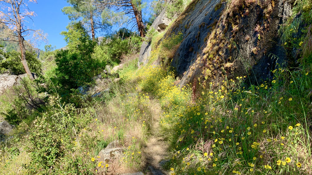
Along the way to Wapama Falls, you’ll come across a couple of intermittent waterfalls as you hike on the north side above the reservoir. The trail to Wapama Falls is wide and double track most of the way. Once you emerge from the canopy and start to hike exposed to the sun, the wildflowers start to appear. We saw White Brodiaea, Indian Paintbrush, Bull Thistle, Clarkia, Harvest Brodiaea, Madia, and Warrior Paintbrush among others.
As we hiked under the sun, there were a few places where water flowed next to or over the trail. We wore sun sleeves to protect our arms from the sun, but we took them off and soaked them in the cool water and put them back on to help keep us cool until they dried out as we hiked.
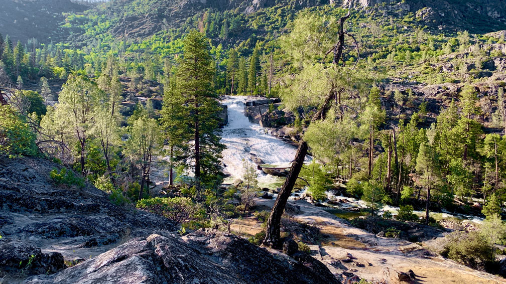
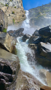
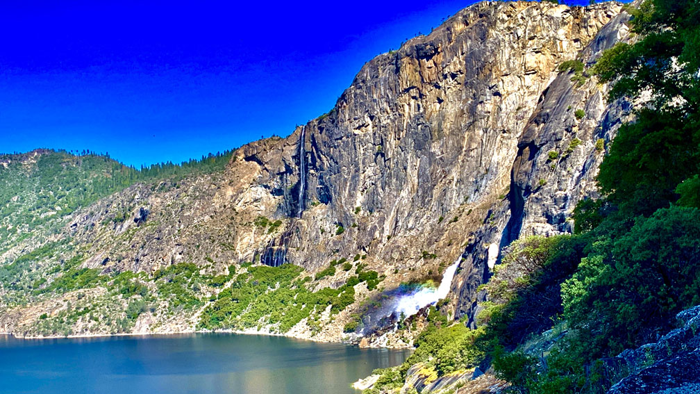
We came to Wapama Falls. The falls were incredible, and the cool mist off them soaked us in the hot mid-day sun before we headed on. Wapama falls is where you leave the city crowd and Instagram posers behind, and where you head into the backcountry.
Along the way, we also encountered a rattlesnake on the trail. It moved past us in the opposite direction as we hiked past it without any incident. It did its thing as we did ours.
About .10 miles from Wapama Falls, you move out of the direct sunlight and head under more canopy, but this is where you’re going to need to get your mosquito net out and cover up any exposed skin, or use some other kind of deterrent. The blood suckers don’t quit for about a mile, and you’ll have to watch your step as poison oak is very prevalent.
When we finally emerged from the canopy, the mosquitos abated, and there were more great views of Hetch Hetchy and wildflowers. We started a descent and hiked down to a bridge crossing at Tiltill Creek next to a waterfall before the final .8 mile climb that emerges into exposure up to the campsite.
As you climb to the campsite, you will see Rancheria Falls and an overlook with them in the background. You can go off the trail and head toward the falls, or continue on the trail to the campsite shortly after you go back under the canopy.
When you enter the campsite, you may want to get your mosquito net back out and pitch your tent. It’s best to find a site where a fire ring is set up. When you pick up your wilderness permit, they will tell you not to create a fire ring.
Once we set up our tent, we headed over to Ranchera Creek and collected water to filter and went back to our site, where the mosquitos swarmed us.
We cooked our food on a jet boil, ate it outside our tent amongst the mosquitos where we took turns swishing them away while the other one took bites and then hopped in our tent and zipped it shut for the night. While backpacking to and from the campsite was very worthwhile, the campsite itself was not a pleasant experience because of the mosquitos. There was no getting away from them.
The next day was slated to be the hottest day so far of the spring, so we got up early, ate breakfast fast, broke down our camp and headed back before the heat from the sun got too hot. We got back much faster than when we came in. Aside from the nearly one mile climb out, the way back was mostly downhill. Another bonus to us leaving so early was that when we got to Wapama Falls, we had the area all to ourselves before the day hikers showed up. It was incredible!
From there, we hiked back to the trailhead.
Directions: From Groveland, take California Highway 120 East for 23 miles to Evergreen Road. Follow Evergreen Road for 7.4 miles to Mather, and turn right onto Hetch Hetchy Road. Follow it for 1.3 miles to the entrance station, and then continue on.
The Skinny
Trail: Rancheria Falls Trail
Trailhead Coordinates: 37.946379, -119.787569
Trailhead Elevation: 3847 Feet
Distance: 12.3 Miles – Out And Back
Level Of Difficulty: 🟡
Average Grade: 2.2%
Steepest Grade: 72% Over 505 Feet
Ascension: 4993 Feet
Trail Condition: 🟢🟢🟢🟢
Scenery: 🟢🟢🟢
Nearest Town: Groveland
Challenges: Exposure, Heat, Temperatures Above 85 Degrees
Traffic: 🥾🥾 To Wapama Falls, 🥾 To Rancheria Falls
Highlights: Wildflowers, Views
Best Time: Spring
Hazards: Exposure, Poison Oak
Wildlife Concerns: Bears, Mosquitoes, Mountain Lions, Rattlesnakes
Cell Service: 📵
Would I Do This Hike Again?: Yes
Parking: $35 Entrance Fee At The Time Of This Writing Good For Seven Days In Yosemite National Park
Red Tape: A Wilderness Permit Is Required For Backpacking In Yosemite
Restrooms: In The Backpacker Camp Near The Trailhead