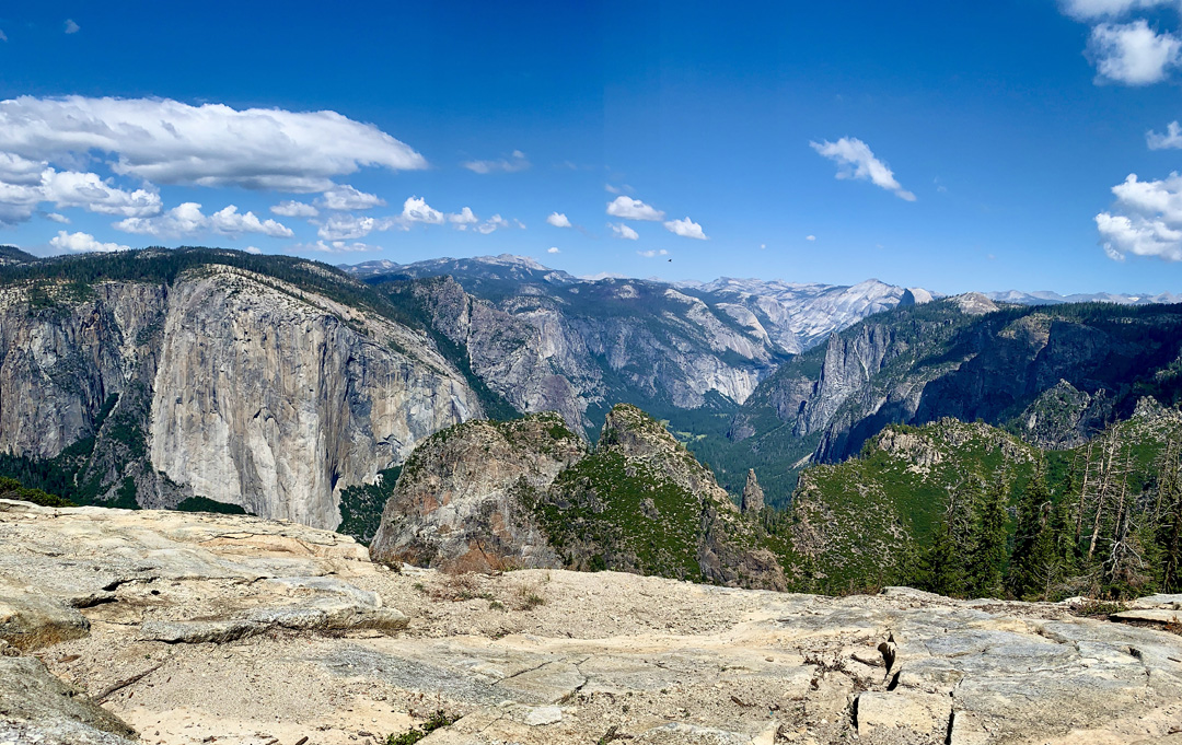
The hike to Dewey Point from the McGurk Meadow Trail in Yosemite National Park is a hike to a fantastic view of El Capitan with Half Dome in the distance and the majestic tops of the Sierra Nevada Mountain Range in the background. While many people do this hike as a day hike, we decided to backpack in and spend the night at Dewey Point.
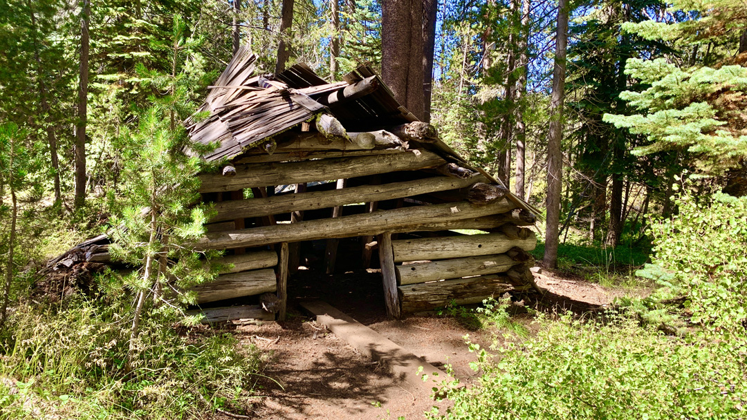
From the beginning of the trailhead at the parking lot, the trail dives right into the forest under the cool canopy as you descend down toward McGurk Meadow. Along the way, we came across McGurk Cabin in a state of decay. It was interesting to see what remains of the cabin, and I wondered what it was like to live in such a setting way back when.
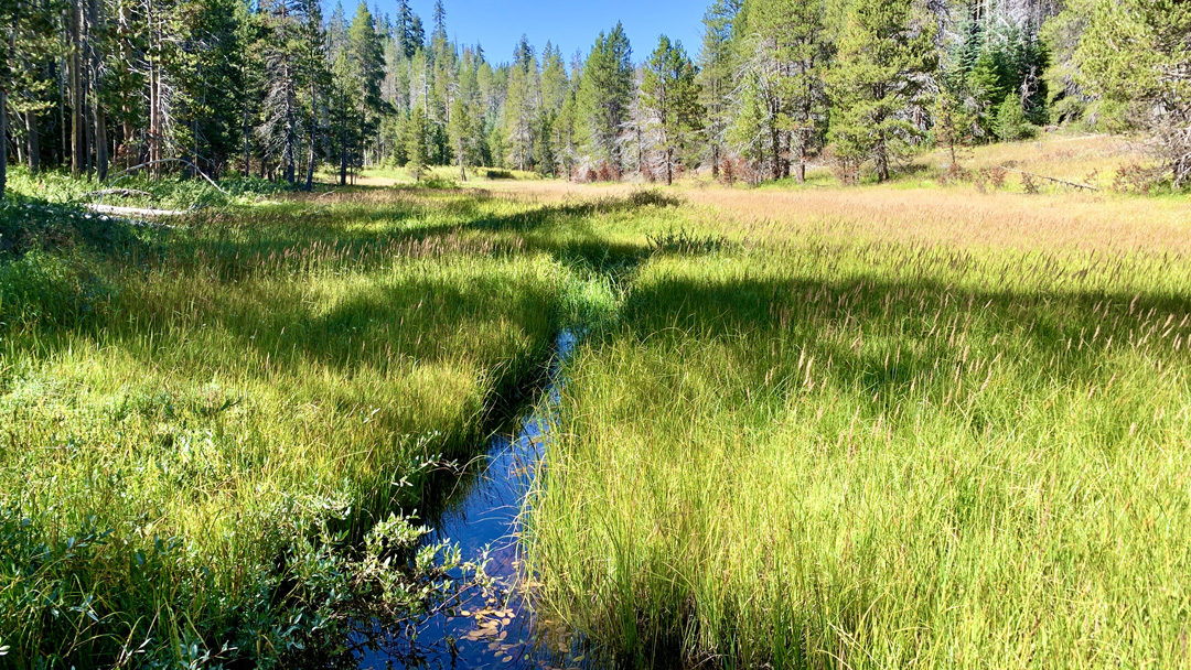
The trail emerged from the canopy as we entered McGurk Meadow where water ran through the tall green grasses that surrounded us. As we hiked in the meadow where there was no cover, it noticeably warmed up on the late summer September day we were there, but it also felt nice when we got back under the shade of the trees.
While hiking along, I took in the flowers as we passed Indian paintbrush, goldenrod, and possibly spiraea. We also saw some small frogs we were not able to identify, a snake that moved too fast to recognize, and a few deer.
After about 1.75 miles, we came to a junction where Bridalveil Creek was to the east and Dewey Point was to the west. Obviously we turned to the west, and we started climbing for almost the entire way for the two remaining miles. For a day hiker, this trail wouldn’t be too difficult, but we had heavy backpacks on, so we moved a bit slower and it was tiring at times.
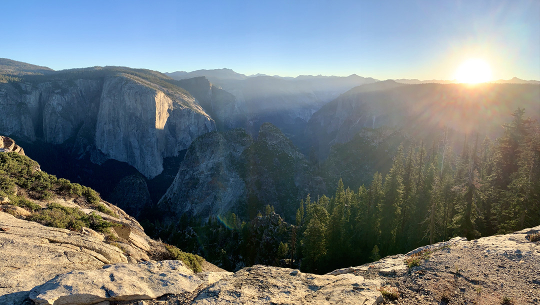
When we made it to Dewey Point, it was breathtaking. There was only one other person there when we arrived, so we pretty much had it to ourselves. We were directly across from El Capitan, and as we looked closely we were able to make out climbers on it even though they looked like little specks on the wall from where we were.
After hanging out at Dewey Point, we thought about going on to Crocker Point, but we held back and found a place to camp just up the hill behind Dewey Point. We found an existing fire ring and set up our tents. I stayed behind to stay with the campsite while the other two went to check out Crocker Point.
From Dewey Point, the views in the distance were incredible, but we could only see limited parts of the valley. From Crocker Point, they said they could see the Valley, Bridalveil Falls, and they had a view similar to what can be seen from the Tunnel View lookout point.
The sunset that evening was nice, but we woke in the morning in time to watch the sunrise over the mountains in the distance. It was beautiful to watch as night turned to day, and the rays of the morning glow beamed onto El Capitan as the sun rose in the sky.
After take sunrise in, we made breakfast, broke camp and headed out. It did not take as long to hike out as it did to hike in, as for the most part we were on a downhill trajectory.
After hiking back, the toughest climb seemed to be the last one – .3 miles on a 9.5 percent grade. That doesn’t sound like a lot, but after hiking nearly four miles with a heavy pack, it took some umph to make it up that hill. Shortly after, we were back at the trailhead and the parking lot.
One of the things that struck us was that we were in Yosemite, one of the most visited National Parks in the system, and we only encountered a little more than a dozen people on our backpacking trip. Most of the active places where there were more people were down in Yosemite Valley and other “high profile” attractions. What we learned is that there are some really awesome places in Yosemite that are majestic but fall in the shadow of the bigger attractions. If you’re checking out these lesser known places in the park that don’t receive the recognition of the others, you’re missing out.
Directions: Inside Yosemite National Park, take Glacier Point Road about 5.4 miles to here: 37.670230, -119.627040. Parking is on the left.
The Skinny
Trail: McGruk Meadow Trail
Trailhead Coordinates: 37.670627, -119.628271
Trailhead Elevation: 7106 Feet
Distance: 8.3 Miles – Out And Back
Level Of Difficulty: 🟡
Average Grade On Overall: 1.4%
Steepest Grade: 11% Over .3 Miles
Ascension: 1470 Feet
Trail Condition: 🟢🟢🟢🟢
Scenery: 🟢🟢🟢🟢
Nearest Town: Yosemite Village
Traffic: 🥾
Highlights: Views
Best Time: Spring, Summer, Fall
Wildlife Concerns: Bears, Mountain Lions, Rattle Snakes
Cell Service: 📵 (AT&T)
Would I Do This Hike Again?: More Than Likely
Parking: At The Time Of This Writing, $35 Valid For Seven Consecutive Days.
Red Tape: A Wilderness Permit Is Required For Backpacking In Yosemite
Restrooms: None